
ASHEBORO N.C. – Fire crews have been dealing with brush and forest fires locally and across the state this month and much-needed rain in the forecast should bring some relief, along with the threat of severe weather.
A local weather station, part of the Community Collaborative Rain, Hail and Snow Network (CoCoRaHS), recorded only 0.06” of rainfall since the beginning of November. Going back to October 1st, only around 1.5” of rainfall has been recorded in Randolph County. Those dry conditions have kept local firefighters busy.
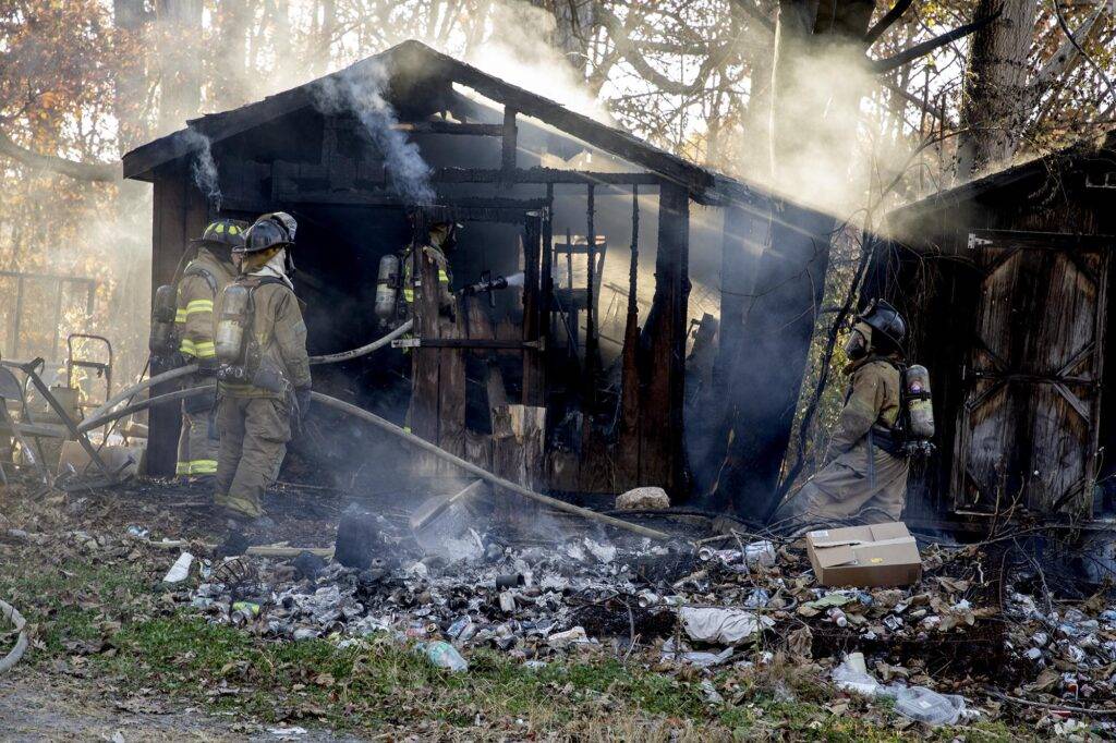
According to officials at Randolph County Emergency Services, as of Nov 13th, firefighters in Randolph County had responded to over 70 brush, grass or woods fires since the beginning of the month. That number has increased since then as fire crews battled at least a dozen grass, brush, and forest fires last week.
That includes an approximately 5 acre brush fire over the weekend near Liberty, in the area of Butler Road, which required the assistance of fire crews from other counties as well as the N.C. Forestry Service to extinguish.
At the state level, the N.C. Forestry Service is currently battling a 300-350 acre fire on Sauratown Mountain in Stokes County, which came after crews were able to put out the Poplar Drive Fire in Henderson County last week.
Releif on the way
Fire crews will be getting some much-need relief in the form of rain, but that rain is bringing with it the threat of severe weather.
According to the National Weather Service Office in Raleigh, rain will likely start late tonight, around 4am., with conditions deteriorating through Tue night as a warm front, a cold front, and additional disturbances aloft move across the region.
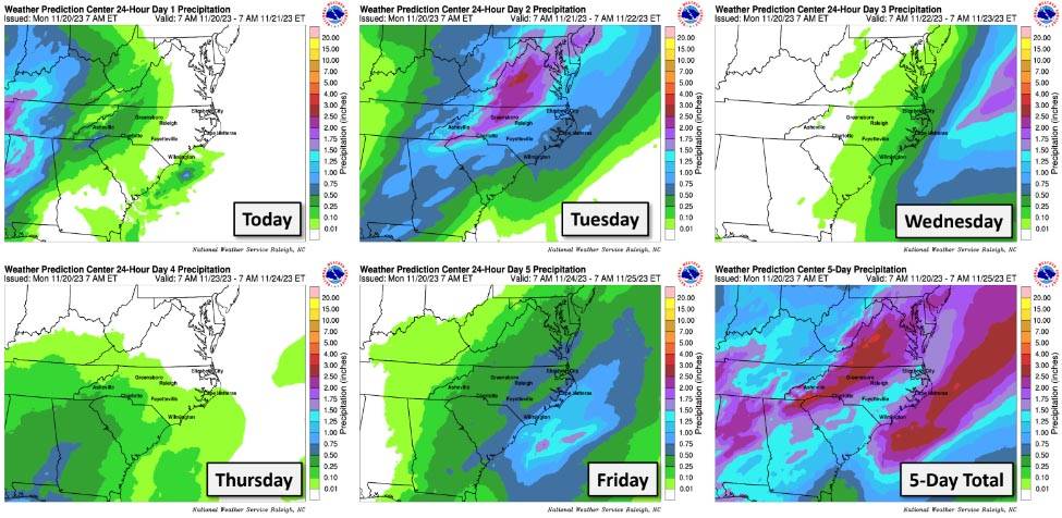
A hazardous weather outlook issued by the NWS warns of a marginal risk for severe storms starting Tuesday through Tuesday night, with damaging wind gusts and an isolated tornado as the primary threats.
High pressure will build across the area late Wed and Thursday with Thanksgiving expected to be sunny, with a high near 60 degrees.
Forecast
Tuesday
Rain, with thunderstorms also possible after 4pm. High near 62. East wind 11 to 15 mph becoming south in the afternoon. Winds could gust as high as 24 mph. Chance of precipitation is 100%. New rainfall amounts between a half and three quarters of an inch possible.
Tuesday Night
Showers and possibly a thunderstorm. Low around 53. South wind 8 to 17 mph becoming southwest after midnight. Winds could gust as high as 28 mph. Chance of precipitation is 90%. New rainfall amounts between three quarters and one inch possible.
Wednesday
Showers likely and possibly a thunderstorm before 7am, then a chance of showers. Partly sunny, with a high near 62. Northwest wind 7 to 9 mph. Chance of precipitation is 60%. New precipitation amounts between a quarter and half of an inch possible.
Wednesday Night
A slight chance of rain before 1am. Partly cloudy, with a low around 36. Northwest wind 7 to 9 mph. Chance of precipitation is 20%.
Thanksgiving Day
Sunny, with a high near 60.