Monday, May 20
Shadow

Tag: Tropical Storm

Tropic Watch – Hurricane Lee

Tropic Watch – Hurricane Lee

Weather
ASHEBORO N.C. - Forecasters will be keeping a very close eye on Hurricane Lee over the weekend to see if forecast models predicting the storm will make a turn out to sea will be accurate. Current Location / Strength 
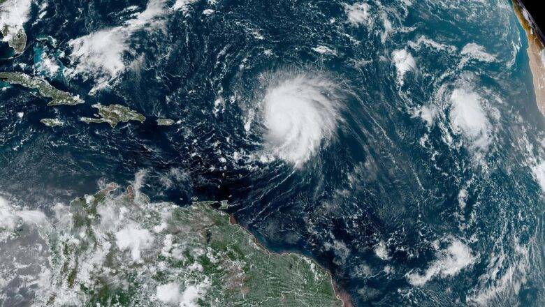
Over less than 24 hours, Lee intensified from a tropical storm into a category 5 hurricane with reported winds of 160+ mph. That rapid intensification is the quickest any system has gone from a tropical storm to a category 5 hurricane in Atlantic hurricane season history. (NOAA / NWS - National Hurricane Center) Lee is currently located around 750 miles to the east of San Juan, Puerto Rico (18.2N 54.5W), and is moving WNW at 13 mph. This morning Lee encountered some wind shear resulting in sustained winds falling below 160 mph dropping Lee back down to a cate...
Tropical Storm Nicole Takes Aim at South-East Local Impacts Expected Tomorrow

Tropical Storm Nicole Takes Aim at South-East Local Impacts Expected Tomorrow

Weather
ASHEBORO N.C. - As Tropical Storm Nicole is nearing Hurricane strength off the coast of Florida forecasters are warning of heavy rains and the risk of tornadoes locally starting as soon as tomorrow afternoon. Timing After moving into Florida, Nicole will eventually turn northeastward and move up across the Carolinas with impacts expected to be felt locally as soon as Thursday afternoon. According to models the first of several bands from Nicole should move across central North Carolina late Thursday afternoon with rain and gusty winds expected to continue and off through Friday night. Impacts Rain will be possible from Thursday evening through Friday evening. The heaviest rain is likely duringFriday morning and Friday evening. For Randolph County 1 to 2 inches of rain ar...
Hurricane Ian & The Triad – Updates

Hurricane Ian & The Triad – Updates

Weather
[ARCHIVED] Last Update: 9/30/22 12:35pm Hurricane Ian from NOAA GOES-16 Satellite. TLDR Ian is just off the Southeast coast, is expected to make landfall along the South Carolina coast later today. This will put Ian on course to move into NC late today, with tropical storm force wind gusts across much of central NC today into tonight. Tropical Storm force winds will be a threat to the local area with gusts of 39 to 57 mph possible.Randolph County Schools and Asheboro City Schools will be closed Friday 9/30. The NC Zoo will be closed on Oct 1st and 2nd, The Asheboro Fall Festival and NASCAR Day scheduled for this weekend have both been canceled. NC Gov has issued a state of emergency. Forecast & Effects Hurricane Ian, located just off the Southeast coast, is expect...
Tropical Storm Colin Forms Off SC Coast | NWS: Minor Impacts For NC

Tropical Storm Colin Forms Off SC Coast | NWS: Minor Impacts For NC

Weather
ASHEBORO N.C. - Those who made the trip down to Myrtle Beach for the holiday weekend are dealing with bands of rain and strong wind gusts after Tropical Storm Colin formed over South Carolina early this morning. At 11am the National Hurricane Center in Florida issued a Tropical Storm Warning for portions of the NC and SC coast. ( A Tropical Storm Warning means that tropical storm conditions are expected somewhere within the warning area within 36 hours.) Forecasters at the National Weather Service Office in Raleigh and the National Hurricane Center are saying that worst of the winds and rain from Colin will likely remain offshore from the Carolinas, with the strongest winds and localized flooding are all expected to stay well east of Raleigh. No wind gusts over 20 mph are ...