
ASHEBORO N.C. – The National Weather Service in Raleigh is warning that an arctic air mass will bring frigid temperatures tonight and into Wednesday, with more dangerously cold temperatures and the threat of winter weather later this week.
According to forecasters at the National Weather Service in Raleigh, a cold front will move across the region today bringing cold rain. Behind that cold front an arctic air will move into central North Carolina mass bringing frigid air and gusty winds of 15 to 20 mph tonight.
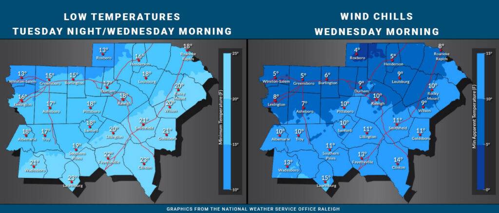
Here in Randolph County, temperatures tonight and into Wednesday morning will plunge to 17 degrees, with windchill values reaching as low as 7 degrees, and that’s just round one.
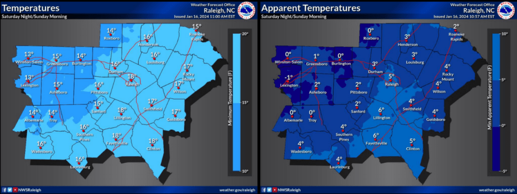
Round two comes Saturday night into Sunday morning when temperatures will again drop to as low as 15 degrees with windchills as low as 2 degrees.
Between the two arctic like nights there is a chance of snow Thursday night, into Friday morning. The main threat for snow will remain NW of Randolph County. Locally, little or no snow accumulation is expected with a few flurries likely overnight Thursday night, into Friday morning, mostly after 1 a.m.
For tonight, forecasters say that while most of the wet ground from recent rain will dry up any residual puddles or runoff will have the potential to freeze late tonight into Wednesday. However, due to the arriving dry air, widespread icy roads or black ice is not expected.
Drivers late tonight through Wednesday morning should remain alert for possible isolated icy spots or patchy black ice through mid-morning Wednesday.
FORECAST
| Tonight | Cloudy during the early evening, then gradual clearing, with a low around 17. Wind chill values as low as 9. North wind 8 to 11 mph, with gusts as high as 18 mph. |
| Wednesday | Sunny, with a high near 37. Wind chill values as low as 10. West wind 5 to 8 mph. |
| Wednesday Night | Clear, with a low around 21. Southwest wind 3 to 5 mph. |
| Thursday | Increasing clouds, with a high near 47. Wind chill values as low as 17 early. Light south wind becoming southwest 5 to 10 mph in the morning. |
| Thursday Night | A chance of snow after 1am. Mostly cloudy, with a low around 31. South wind around 6 mph. Chance of precipitation is 40%. Little or no snow accumulation expected. |
| Friday | Partly sunny, with a high near 49. |
| Friday Night | Mostly clear, with a low around 17. |
| Saturday | Sunny, with a high near 31. |
| Saturday Night | Clear, with a low around 13. |
