
ASHEBORO N.C. – Ahead of expected heavy rain, strong winds, and the threat of flash flooding on Tuesday the National Weather Service office in Raleigh has issued a Flash Flood Watch and Wind Advisory for much of central N.C. including Randolph County.
According to forecasters, a strong storm system will bring widespread heavy rain, gusty to damaging winds, and the threat of a few tornadoes to central N.C. on Tuesday January 9th, 2024.
Severe weather is expected to begin to arrive in Randolph County starting as soon as noon on Tuesday and is expected to continue until late into the night.
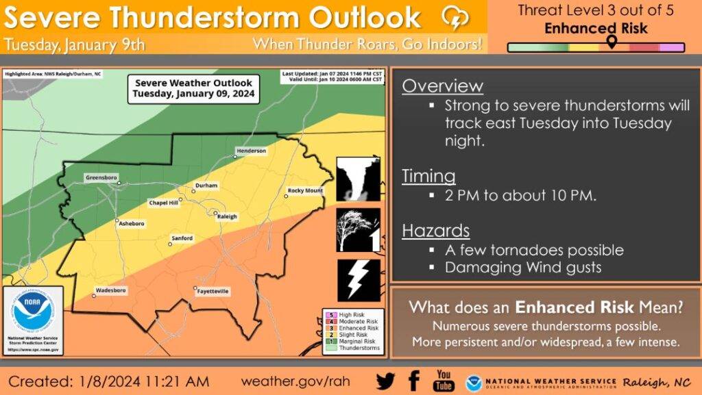
WIND – South or southeasterly winds will increase to 15 to 25 mph, with gusts between 35 and 45 mph expected during the afternoon and evening Tuesday. Gusty winds could blow around unsecured objects. Tree limbs could be blown down and a few power outages may result. A few tornadoes are possible. The Storm Prediction Center places Randolph County under a 5-9% chance of a tornado.
RAIN – Storm total rainfall early Tuesday through Tuesday night will range from 1.5 to 2 inches, with Randolph County expected to see 2–2.5”. Excessive runoff may result in flooding of rivers, creeks, streams, and other low-lying and flood-prone locations. Isolated/scattered flash flooding is possible.
“Residents across central NC should be prepared for windy, wet, and potentially adverse weather late on Tuesday,” said NWS officials in a briefing. “Make sure you know where to seek shelter if warnings are issued for your area if you see or hear threatening weather approaching. Remember, never drive through area where water covers the road.”
UPDATE – 1/8/24 4:45 PM – Randolph County and Asheboro city schools have both announced they will releasing students three hours early and canceling after-school activities tomorrow.
See our Closings / Delays page for a full list of weather related closings.
FORECAST
Tonight – Rain, mainly after 4am. Low around 34. Light east wind increasing to 8 to 13 mph in the evening. Chance of precipitation is 80%. New precipitation amounts between a tenth and quarter of an inch possible.
Tuesday – Rain before 1pm, then showers and possibly a thunderstorm, mainly after 1pm. Some of the storms could produce heavy rainfall. High near 62. Breezy, with an east wind 13 to 21 mph becoming south in the afternoon. Winds could gust as high as 40 mph. Chance of precipitation is 100%. New rainfall amounts between 1 and 2 inches possible.
Tuesday Night – Showers and thunderstorms likely before 11pm, then a slight chance of showers between 11pm and 4am. Some of the storms could produce heavy rain. Mostly cloudy, with a low around 38. Southwest wind around 18 mph, with gusts as high as 39 mph. Chance of precipitation is 60%. New precipitation amounts between a quarter and half of an inch possible.
Residents are encouraged to have a way to receive weather alerts such as a weather radio or through Randolph County’s REACT notification system.
“Remember, Turn Around, Don’t Drown”