Tuesday, May 21
Shadow

Tag: Power Outages

Strong Bitterly Cold Winds Knocking Down Trees, Causing Power Outages

Strong Bitterly Cold Winds Knocking Down Trees, Causing Power Outages

Breaking News
WIND CHILL ADVISORY REMAINS IN EFFECT FROM 7 PM THIS EVENING TO 9 AM EST SATURDAY 
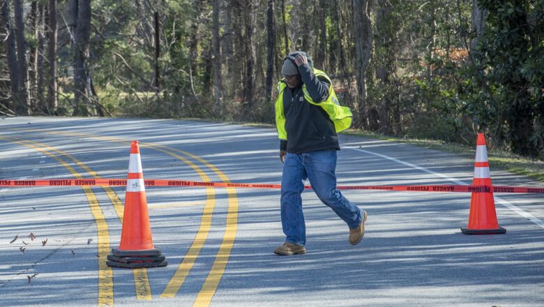
A worker with NC DOT places cones out on Central Falls Rd near Old Liberty Rd due to power lines in the roadway from a fallen tree (Scott Pelkey / Acme News) ASHEBORO N.C. - Wind gusts of near 30 mph this morning are downing trees and have dropped the wind chill value to the mid-teens just as power outages start to stack up, and its probably going to get worse as the day goes on. Forecasters are expecting frequent wind gusts of 30 to 40 mph through this evening with a surge of gusts of 40 to 50 mph and isolated gusts of around 55 mph, between 6 AM and 10 AM. These strong winds combined with the bitter arctic air are posing a threat of any remaining moisture refreezing. "As temperatures rapidly ...
Overnight Winter Weather Drops Snow Across Randolph

Overnight Winter Weather Drops Snow Across Randolph

Weather
ASHEBORO N.C. - Overnight a winter weather system dropped 1-2.5 inches of snow across Randolph County and wreaked havoc on roadways. The snow combined with already wet roads and overnight lows that dipped down below 10 degrees created treacherous driving conditions. In Moore county the Sandhills Sentinel reported several vehicles overturned including a NCDOT snow plow and a FEDEX delivery van. Here in Randolph County impacts have been minimal. Percriptitation was almost all snow with very little in the way of sleet or freezing rain. Unlike the last snow storm this one left several inches of alight powdery snow perfect for building a snowman . Crews were clearing roads as soon as snowfall stopped at 4am. Interstates and highways have been cleared of snow and ice, main road...
Live Storm Updates – Randolph County

Live Storm Updates – Randolph County

Weather
At around 1pm DOT crews were working to clear snow from the 73./74 interchange at Sunset Ave, but DOT is still reporting all interstates, highways, and roads in Randolph as "Covered With Snow/Ice". SPECIAL WEATHER STATEMENT Black ice expected from late this evening through Tuesday morning Temperatures will quickly fall below freezing after sunset this evening. Lingering wet roads due to snow melt will result in black ice as the liquid re-freezes. Black ice is difficult to see. Use caution while traveling. HAZARDOUS WEATHER OUTLOOK Frequent gusts between 30 to 40 mph can be expected today. Any trees or tree limbs weakened by ice could fall, resulting in additional scattered power outages. Unsecured objects may be blown around by these winds. JAN 16TH 2022 - 11:30 A.M....
Power Outages & Treacherous Roads Likely  As Forecast Calls For Less Snow/More Ice

Power Outages & Treacherous Roads Likely As Forecast Calls For Less Snow/More Ice

Weather
ASHEBORO N.C. - Over the last 48 hours, as the start of the winter storm gets closer, meteorologist have been watching their forecast models closely. Now, just hours before snow and sleet are set to start, new forecasts are changing the amount of snow and ice we can expect, with warnings of widespread power outages and treacherous travel conditions. WINTER STORM WARNING At 3am this morning, the National Weather Service (NWS) in Raleigh upgraded the Winter Storm Watch for our area to a Winter Storm Warning, starting at midnight tonight. Meteorologist are calling for heavy mixed precipitation (snow, sleet, & freezing rain) with total snow accumulations of up to 3 inches and ice accumulations of two tenths to three tenths of an inch, with winds gusts as high as 40 mph. TIMELINE...
Gone With The Wind – Morning Snow Causes Headaches, Whats Next?

Gone With The Wind – Morning Snow Causes Headaches, Whats Next?

Weather
ASHEBORO N.C. — As fast as it came, it left. After a week of unusually warm weather, rain, strong winds and the first snowfall of the year brought headaches throughout Randolph County. The system responsible for todays snow was expected to drop some wintery mix mostly in the northern parts of the triad turned out to be stronger than expected according to Scotty Powell, a Meteorologist with Carolina Weather Group. "So the precipitation was a little heavier which allowed colder air to the surface. So that is why some areas was able to see snow that wasn't necessarily supposed to" said Powell. The National Weather Service in Raleigh issued a Wind Advisory as well as several flash flood watches in the early morning hours. The majority of the headache came fro...